
พิกัด MGRS(Military Grid Reference System)
2 posters
THAITOPO บอร์ดแสดงวิสัยทัศน์ด้านGIS 2006-2017 :: CAD & GIS & GPS & MAPS : ร่วมแสดงวิสัยทัศน์ แลกเปลี่ยนความรู้
หน้า 1 จาก 1

พิกัด MGRS(Military Grid Reference System)
by thaitopo Mon Nov 05, 2007 3:52 pm
ễ??蒾ԡѴ MGRS= Military Grid Reference System
?ч͂蒧?ԡѴἹ?ը?˒à(MGRS Reference) ?18SUU8362601432? :
- UTM longitude zone = 18
- UTM latitude zone = S
- ID ?ͧ??. 100,000 x 100,000 ? = UU
- Easting = 83626 (?ǒ?Р͕´ 1 ?)
- Northing =01432 (?ǒ?Р͕´ 1 ?)
DOWNLOAD
http://www.mentorsoftwareinc.com/FREEBIE/FREE0100.HTM
EXCEL ON WEB
http://www.uwgb.edu/dutchs/UsefulData/UTMConversions1.xls
แก้ไขล่าสุดโดย thaitopo เมื่อ Fri Aug 01, 2008 4:46 pm, ทั้งหมด 1 ครั้ง

thaitopo- Admin
- จำนวนข้อความ : 1571
���� : 30
Localisation : chiengmai
Registration date : 24/10/2006 -

Re: พิกัด MGRS(Military Grid Reference System)
by thaitopo Sun Nov 11, 2007 3:24 pm
�Ѵ�͡�������Ҩҡ�س beeline �ҡ thaiMtb
MGRS �����ѺἹ������ ���к��кص��˹� ������ʹ�Ҩҡ�к� Universal Transverse Mercator (UTM)
���˹�˹��㴵��˹�˹�觨��к�����¾ԡѴ MGRS ˹�� ��觻�Сͺ���� 5 ��ǹ (������Ѻ����кؾԡѴ��к� Geographic Coordinates ���µ���Ţ 2 �ش��� latitude ��� longitude)
��ǹ��� 1:
�����Ţ�ͧ��Ƿ�����к� UTM ⫹ ���������ǧ (UTM Longitude Zone)
���͡�� 60 ⫹ �������Ţ����� 1 (����ǧ��� 180 ͧ�ҵ��ѹ��) �֧ 60 ����⫹�С��ҧ 6 ͧ�� ���������ǧ
��ǹ��� 2:
����ѡ��˹�觵�Ƿ�����к� UTM ⫹ ����������駢ͧ (UTM Latitude Zone)
����⫹���٧ 8 ͧ�� ����������� ��Ш��ժ����繵���ѡ�èҡ C (�����駷�� 80 ͧ����) �֧ X ¡����ѡ�� I ��� O ���͡ѹ�������Ѻʹ�Ѻ����Ţ 1 ��� 0
��ǹ��� 3:
����ѡ���ͧ��Ƿ�����кؾ�鹷�袹Ҵ 100,000 �. x 100,000 �. (100,000m Square Identification)
UTM ⫹����⫹�վ�鹷�� 10,000 ���ҧ��. ��觨��к������ѡ���ͧ��� ����á����ǵ��� (row) ��Ƿ���ͧ����ǵ����� (column)
Row ID ��������ҡ A �֧ V (¡��� I ��� O) �¨Ы�ӡѹ价ء� 2,000 ��. �ҡ����ٹ���ٵ�
Column ID ��������ҡ A �֧ Z (¡��� I ��� O)
��ǹ��� 4 ��� 5:
�ǵ��仴�ҹ���ѹ�͡ (Easting) ����ǹ仴�ҹ�˹�� (Northing)
��鹷�� 10,000 ��.��. �ѧ����Ƕ١������ŧ��ա�繾�鹷�����դ��������´ 10,000 �., 1,000 �., 100 �., 10 �., ��� 1 �.
Easting ��� Northing ���к�����µ���Ţ 5 ��� (����Ѻ���������´�дѺ 1 �.) ���դ������������������������ҧ�ͧ UTM ⫹
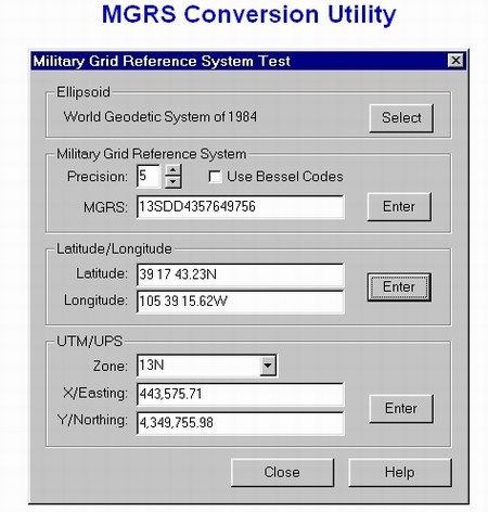
¡������ҧ�ԡѴἹ������ (MGRS Reference) �18SUU8362601432� :
- UTM longitude zone = 18
- UTM latitude zone = S
- ID �ͧ��. 100,000 x 100,000 �. = UU
- Easting = 83626 (���������´ 1 �.)
- Northing =01432 (���������´ 1 �.)
�к� UTM ��� Ἱ�����ù���� �����Ҩд�����ҡ㹵�á �������ҡ�ѡ���������
UTM �բ�ʹդ�͡�˹��ش��Ἱ��� (��� support UTM) ����� ������Ѻ�����ҹ�Ţ����ҹ������ ��������椹������¡Ѻ�����ʶҹ���ҡἹ����д�ɡѹ�¡�ä鹨ҡ���ҧ (⫹) ����˹�����鹵���ǹ����ǵ�� ��������Ἱ����д�ɹ��� ��觡�����ѡ��ä�����ѹ�Ѻ�����Ѻ UTM/MGRS ������������� 㹡�����º��º�ѹ ����кؾԡѴ�����������������ǧ �е�ͧ������������������ҡ���ҹ��
�� 㹺ҧ����� (�����Ѱ����ԡ�) ��������й� UTM ����㹡���кص��˹觺�Ἱ������ҵðҹ ���ͧ�ҡ�������º���� ��������¢ͧ�ѹ
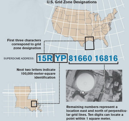
������ҧ�ٻ���Ṻ�Ң�ҧ�� ������� (�ԡѴ) �ͧ �ػ��������Ѱ�����¹�� (Louisiana) �ͧ����ԡҤ�� 15RYP8166016816 ��觨к͡��������� grid 81660 �. 价ҧ��ҹ���ѹ�͡ 016816 �. 价ҧ��ҹ�˹�� (grid ����ͧ��˹�ҷ�����º�ҹ�Ţ���) �ͧ ��鹷�� YP (�����������) ��� ⫹ 15R ��Ἱ��� (������ѧ��Ѵ)
������ͧ�Ѻ�վ������������㹻Ѩ�غѹ �� GPSMap 60Cx/CSx ����ö�������͡ Position format �� UTM (Universal Transverse Mercator)/UPS (Universal Polar Stereographic) ��͡�˹�ͨҡ dd mm.mmmm (���� Geographic Coordinates format ����) �ѧ����Ҩ���� ����ͧ�Ѻ�վ���ʴѧ������ŧ UTM �� Geographic Coordinates (���͡�Ѻ�ѹ) �¡�����͡ Position format ��Ѻ仡�Ѻ�� �������͡���ͧ�Ӵ� �й����ʵ������Ѻ
��ѧ��Ҥ����µͺ�Ӷ���س���ҧ����ҡ����¤�Ѻ
From : beeline [ 18 ��.�. 50 - 11:41:49 �. ]
MGRS �����ѺἹ������ ���к��кص��˹� ������ʹ�Ҩҡ�к� Universal Transverse Mercator (UTM)
���˹�˹��㴵��˹�˹�觨��к�����¾ԡѴ MGRS ˹�� ��觻�Сͺ���� 5 ��ǹ (������Ѻ����кؾԡѴ��к� Geographic Coordinates ���µ���Ţ 2 �ش��� latitude ��� longitude)
��ǹ��� 1:
�����Ţ�ͧ��Ƿ�����к� UTM ⫹ ���������ǧ (UTM Longitude Zone)
���͡�� 60 ⫹ �������Ţ����� 1 (����ǧ��� 180 ͧ�ҵ��ѹ��) �֧ 60 ����⫹�С��ҧ 6 ͧ�� ���������ǧ
��ǹ��� 2:
����ѡ��˹�觵�Ƿ�����к� UTM ⫹ ����������駢ͧ (UTM Latitude Zone)
����⫹���٧ 8 ͧ�� ����������� ��Ш��ժ����繵���ѡ�èҡ C (�����駷�� 80 ͧ����) �֧ X ¡����ѡ�� I ��� O ���͡ѹ�������Ѻʹ�Ѻ����Ţ 1 ��� 0
��ǹ��� 3:
����ѡ���ͧ��Ƿ�����кؾ�鹷�袹Ҵ 100,000 �. x 100,000 �. (100,000m Square Identification)
UTM ⫹����⫹�վ�鹷�� 10,000 ���ҧ��. ��觨��к������ѡ���ͧ��� ����á����ǵ��� (row) ��Ƿ���ͧ����ǵ����� (column)
Row ID ��������ҡ A �֧ V (¡��� I ��� O) �¨Ы�ӡѹ价ء� 2,000 ��. �ҡ����ٹ���ٵ�
Column ID ��������ҡ A �֧ Z (¡��� I ��� O)
��ǹ��� 4 ��� 5:
�ǵ��仴�ҹ���ѹ�͡ (Easting) ����ǹ仴�ҹ�˹�� (Northing)
��鹷�� 10,000 ��.��. �ѧ����Ƕ١������ŧ��ա�繾�鹷�����դ��������´ 10,000 �., 1,000 �., 100 �., 10 �., ��� 1 �.
Easting ��� Northing ���к�����µ���Ţ 5 ��� (����Ѻ���������´�дѺ 1 �.) ���դ������������������������ҧ�ͧ UTM ⫹
¡������ҧ�ԡѴἹ������ (MGRS Reference) �18SUU8362601432� :
- UTM longitude zone = 18
- UTM latitude zone = S
- ID �ͧ��. 100,000 x 100,000 �. = UU
- Easting = 83626 (���������´ 1 �.)
- Northing =01432 (���������´ 1 �.)
�к� UTM ��� Ἱ�����ù���� �����Ҩд�����ҡ㹵�á �������ҡ�ѡ���������
UTM �բ�ʹդ�͡�˹��ش��Ἱ��� (��� support UTM) ����� ������Ѻ�����ҹ�Ţ����ҹ������ ��������椹������¡Ѻ�����ʶҹ���ҡἹ����д�ɡѹ�¡�ä鹨ҡ���ҧ (⫹) ����˹�����鹵���ǹ����ǵ�� ��������Ἱ����д�ɹ��� ��觡�����ѡ��ä�����ѹ�Ѻ�����Ѻ UTM/MGRS ������������� 㹡�����º��º�ѹ ����кؾԡѴ�����������������ǧ �е�ͧ������������������ҡ���ҹ��
�� 㹺ҧ����� (�����Ѱ����ԡ�) ��������й� UTM ����㹡���кص��˹觺�Ἱ������ҵðҹ ���ͧ�ҡ�������º���� ��������¢ͧ�ѹ
������ҧ�ٻ���Ṻ�Ң�ҧ�� ������� (�ԡѴ) �ͧ �ػ��������Ѱ�����¹�� (Louisiana) �ͧ����ԡҤ�� 15RYP8166016816 ��觨к͡��������� grid 81660 �. 价ҧ��ҹ���ѹ�͡ 016816 �. 价ҧ��ҹ�˹�� (grid ����ͧ��˹�ҷ�����º�ҹ�Ţ���) �ͧ ��鹷�� YP (�����������) ��� ⫹ 15R ��Ἱ��� (������ѧ��Ѵ)
������ͧ�Ѻ�վ������������㹻Ѩ�غѹ �� GPSMap 60Cx/CSx ����ö�������͡ Position format �� UTM (Universal Transverse Mercator)/UPS (Universal Polar Stereographic) ��͡�˹�ͨҡ dd mm.mmmm (���� Geographic Coordinates format ����) �ѧ����Ҩ���� ����ͧ�Ѻ�վ���ʴѧ������ŧ UTM �� Geographic Coordinates (���͡�Ѻ�ѹ) �¡�����͡ Position format ��Ѻ仡�Ѻ�� �������͡���ͧ�Ӵ� �й����ʵ������Ѻ
��ѧ��Ҥ����µͺ�Ӷ���س���ҧ����ҡ����¤�Ѻ
From : beeline [ 18 ��.�. 50 - 11:41:49 �. ]
thaitopo- Admin
- จำนวนข้อความ : 1571
���� : 30
Localisation : chiengmai
Registration date : 24/10/2006 -
����� LocConv
by thaitopo Mon Nov 19, 2007 3:51 pm

http://www.mediafire.com/download.php?7zyomik2l2t
����� LocConv ����ö�ŧ�ԡѴ㴡��� ��ٻẺ��������ѹ 5 ��Դ�ѧ���
(1.) hddd.ddddd (Lat/Lon Decimal Degree) ����ٻẺ ͧ�ҷȹ���
(2.) hddd mm.mmm (Lat/Lon Degree, Decimal Minute) ����ٻẺ ͧ�� �Ի�ҷȹ���
(3.) hddd mm ss.s (Lat/Lon Degree, Minute, Decimal Second) ����ٻẺ ͧ�� �Ի�� ���Ի�ҷȹ���
(4.) UTM (Universal Transverse Mercator) �����㹡Ԩ��þ��������������
(5.) MGRS (Military Grid Reference System) �����㹡Ԩ��÷���
������繷�� 3

����Ѻ�����ҹ�� PPC, �Menu� ��ҹ������ҧ����ٻ���յ�����͡�ѧ���
���͡ �About� �����ʴ����������������������������ҧ������繼��Ѳ��

���͡ �EULA� �����ʴ���͵�ŧ㹡����ҹ (End User License Agreement)
���͡ �Help� �����ʴ������ŷ�����������㨡����ҹ ��Тմ�ӡѴ�ͧ��������
���͡ �Convert� �����ŧ�ԡѴ �����Ѻ��á����� �Convert�
���͡ �Exit� ������ԡ��ҹ��лԴ�����
�� �Menu� �������ҹ���º��������ҹ�� PC
������������ö��ҹ���駺� PPC ��� PC 㹡ó���ҹ�� PPC ���� program memory ����ҳ 435.5 KB
㹡óշ���ջѭ���������ö run �����������ͧ�Դ�����������仹��
(1.) PPC
�Դ�������� �.NET Compact Framework 2.0� ��� download ��ҡ�����
http://www.microsoft.com/downloads/details.aspx?familyid=9655156b-356b-4a2c-857c-e62f50ae9a55&displaylang=en
(2.) PC
�Դ�������� �Microsoft .NET Framework Version 2.0� ��� download ��ҡ�����
http://www.microsoft.com/downloads/details.aspx?familyid=0856eacb-4362-4b0d-8edd-aab15c5e04f5&displaylang=en
From : beeline [ 19 �.�. 50 - 11:38:15 �. ]
thaitopo- Admin
- จำนวนข้อความ : 1571
���� : 30
Localisation : chiengmai
Registration date : 24/10/2006 -
Re: พิกัด MGRS(Military Grid Reference System)
by lersak Mon Nov 19, 2007 5:41 pm
�ͺ�س��Һ ���ͧ������蹴�
lersak- จำนวนข้อความ : 327
Registration date : 01/11/2006
» vba&gridline1 ( for maps )
» Coordinate System ของประเทศไทย ใน civil 3D ใช้ตัวไหนครับ
» เวปไฟป่า ต้นแบบ 2008
» Coordinate System ของประเทศไทย ใน civil 3D ใช้ตัวไหนครับ
» เวปไฟป่า ต้นแบบ 2008
THAITOPO บอร์ดแสดงวิสัยทัศน์ด้านGIS 2006-2017 :: CAD & GIS & GPS & MAPS : ร่วมแสดงวิสัยทัศน์ แลกเปลี่ยนความรู้
หน้า 1 จาก 1
Permissions in this forum:
คุณไม่สามารถพิมพ์ตอบ|
|
|